Geolocate

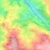
Mittweida topographic map

Click on the map to display elevation.

About this map
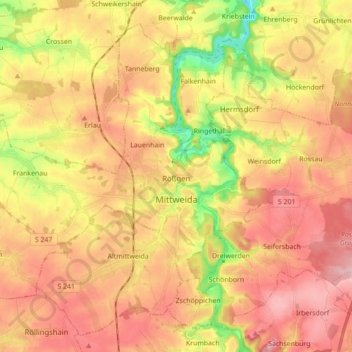
Name: Mittweida topographic map, elevation, terrain.

Location: Mittweida, Mittelsachsen, Saxony, 09648, Germany (50.94498 12.86708 51.04033 13.04154)

Average elevation: 296 m

Minimum elevation: 195 m

Maximum elevation: 368 m

Other topographic maps

Click on a map to view its topography, its elevation and its terrain.

Rosine

Germany > Saxony > Mittelsachsen > Freiberg

Average elevation: 420 m

Ullersdorf

Germany > Saxony > Mittelsachsen > Sayda

Average elevation: 644 m

Clausnitz

Germany > Saxony > Mittelsachsen

Average elevation: 609 m

Holzhau

Germany > Saxony > Mittelsachsen

Average elevation: 725 m

Seifersdorf

Germany > Saxony > Mittelsachsen > Hartha

Average elevation: 248 m

Dittmannsdorf

Germany > Saxony > Mittelsachsen > Penig

Average elevation: 250 m

Erdmannsdorf

Germany > Saxony > Mittelsachsen > Augustusburg

Average elevation: 376 m

Tuttendorf

Germany > Saxony > Mittelsachsen

Average elevation: 376 m

Gear up for your next adventure:

🛌Insulated Sleeping Pad - Critical thermal barrier between you and the cold ground
🥾Mountaineering Boots - Supportive boots for climbing and high-altitude hiking
🧼Biodegradable Camp Soap - Environmentally friendly cleaning for gear and body
💡LED Headlamp - Hands-free illumination for night hiking and camping
🧢Sun Protection Cap - Breathable cap to protect from sun exposure

As an Amazon Associate, this site earns from qualifying purchases at no extra cost to you.