
Thank you for supporting this site ❤️
Make a donation
Make a donation
Gear up for your next adventure:
As an Amazon Associate, this site earns from qualifying purchases at no extra cost to you.
Seifersdorf topographic map
Click on the map to display elevation.
Thank you for supporting this site ❤️
Make a donation
Make a donation
Gear up for your next adventure:
As an Amazon Associate, this site earns from qualifying purchases at no extra cost to you.
About this map
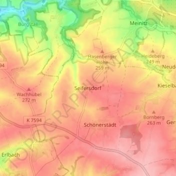
Name: Seifersdorf topographic map, elevation, terrain.
Location: Seifersdorf, Hartha, Mittelsachsen, Saxony, 04703, Germany (51.10895 12.88529 51.14895 12.92529)
Average elevation: 248 m
Minimum elevation: 164 m
Maximum elevation: 293 m
Thank you for supporting this site ❤️
Make a donation
Make a donation
Gear up for your next adventure:
As an Amazon Associate, this site earns from qualifying purchases at no extra cost to you.