
Make a donation
Gear up for your next adventure:
As an Amazon Associate, this site earns from qualifying purchases at no extra cost to you.
West Champaran District topographic map
Click on the map to display elevation.
Make a donation
Gear up for your next adventure:
As an Amazon Associate, this site earns from qualifying purchases at no extra cost to you.
About this map
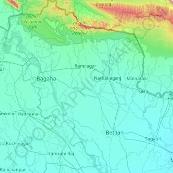
Name: West Champaran District topographic map, elevation, terrain.
Location: West Champaran District, Bihar, India (26.58218 83.83707 27.52164 84.76069)
Average elevation: 132 m
Minimum elevation: 64 m
Maximum elevation: 999 m
Make a donation
Gear up for your next adventure:
As an Amazon Associate, this site earns from qualifying purchases at no extra cost to you.
Other topographic maps
Click on a map to view its topography, its elevation and its terrain.
Araria
Araria is located at 26°09′N 87°31′E / 26.15°N 87.52°E / 26.15; 87.52.[7] It has an average elevation of 47 metres (154 feet). Araria is situated at the northern part of Purnia and Madhepura in Bihar. Borders of Araria are surrounded by Nepal on the northern side, Kishanganj on the eastern…
Average elevation: 50 m
Gaya
India > Bihar > Gaya Town C.D.Block > Gaya
Gaya Junction railway station is a junction station serving the city. Gaya Junction was the only station in Bihar and Jharkhand in the list of 66 stations to be built to international standards drawn up by Minister of Railways Mamata Banerjee. Gaya falls under the jurisdiction of the Mughalsarai railway…
Average elevation: 111 m
Make a donation
Gear up for your next adventure:
As an Amazon Associate, this site earns from qualifying purchases at no extra cost to you.
Forbesganj
India > Bihar > Forbesganj
Forbesganj is located at 26°18′N 87°15′E / 26.3°N 87.25°E / 26.3; 87.25.[4] It has an average elevation of 46 meters (150 feet). The Nepalese border is only 12 km away.
Average elevation: 61 m