Geolocate

Fellsmere topographic map

Click on the map to display elevation.

About this map
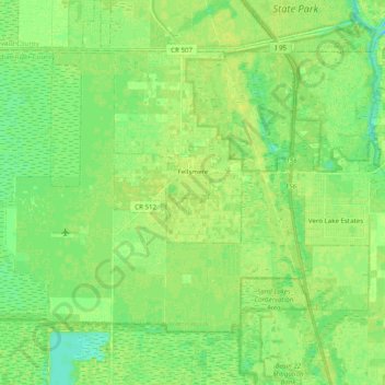
Name: Fellsmere topographic map, elevation, terrain.

Location: Fellsmere, Indian River County, Florida, 32948, United States (27.69518 -80.70809 27.82164 -80.51136)

Average elevation: 8 m

Minimum elevation: -2 m

Maximum elevation: 13 m

Other topographic maps

Click on a map to view its topography, its elevation and its terrain.

Gifford

United States > Florida > Indian River County

Average elevation: 7 m

Gear up for your next adventure:

🛏️Camping Sleeping Mat - Comfortable mats for sleeping outdoors
⛺Lightweight Camping Tent - Portable shelter optimized for Canadian backcountry camping
🧤Insulated Winter Gloves - Heavy-duty protection for sub-zero Canadian adventures
🥾Trail Hiking Shoes - Durable shoes designed for rugged trails
🕯️Camping Lantern - Illuminates your entire campsite with high-efficiency LEDs

As an Amazon Associate, this site earns from qualifying purchases at no extra cost to you.