
Cody topographic map
Click on the map to display elevation.
Cody
Cody's elevation is approximately 5016 ft (1,500 m) above sea level. The main part of the city is split across three levels, separated by about 60 feet (18 m).
About this map
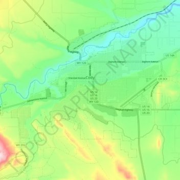
Name: Cody topographic map, elevation, terrain.
Location: Cody, Park County, Wyoming, United States (44.48981 -109.12048 44.55131 -109.00576)
Average elevation: 1,557 m
Minimum elevation: 1,436 m
Maximum elevation: 1,798 m
Other topographic maps
Click on a map to view its topography, its elevation and its terrain.
Mount Washburn
United States > Wyoming > Park County
Mount Washburn, elevation 10,219 feet (3,115 m), is a prominent mountain peak in the Washburn Range in Yellowstone National Park, Wyoming. The peak was named in 1870 to honor Henry D. Washburn, leader of the Washburn–Langford–Doane Expedition. The Washburn Range is one of two mountains ranges completely…
Average elevation: 2,798 m
Druid Peak
United States > Wyoming > Park County
Druid Peak (elevation 9,577 feet (2,919 m)) is a moderate domed peak on the southern flank of the Absaroka Range in Yellowstone National Park. The peak lies just north of the Lamar River and Soda Butte Creek confluence at the head of the Lamar Valley. Prior to 1885, this summit was named Soda Hill by members…
Average elevation: 2,597 m
Hayden Valley
United States > Wyoming > Park County
A grassy valley, branching between low ridges, running from the river toward the center of the basin. A small stream rose in this valley, breaking through the ridges to the west in a deep cañon, and falling into the channel of the Yellowstone, which here bears in a northeast course, flowing in view as far as…
Average elevation: 2,373 m