Geolocate

Bukit Kapur topographic map

Click on the map to display elevation.

About this map

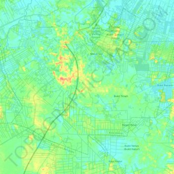
Name: Bukit Kapur topographic map, elevation, terrain.

Location: Bukit Kapur, Dumai City, Riau, Sumatra, 28882, Indonesia (1.44720 101.30387 1.61630 101.52612)

Average elevation: 12 m

Minimum elevation: -1 m

Maximum elevation: 47 m

Other topographic maps

Click on a map to view its topography, its elevation and its terrain.

Basilam Baru

Indonesia > Riau > Dumai City

Average elevation: 6 m

Gear up for your next adventure:

Tent Footprint - Protect tent floor and increase durability
🔥Emergency Fire Starter - Reliable ignition source for all weather conditions
🦯Trekking Poles - Reduced impact on joints for steep topographic climbs
🔋Solar Power Bank - Keep your GPS and devices charged during long outdoor trips
🎒Hiking Backpack - Lightweight and ergonomic backpacks for day hikes or multi-day treks

As an Amazon Associate, this site earns from qualifying purchases at no extra cost to you.