Geolocate

Delta topographic map

Click on the map to display elevation.

About this map

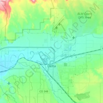
Name: Delta topographic map, elevation, terrain.

Location: Delta, Delta County, Colorado, 81416, United States (38.71402 -108.15735 38.80271 -108.02174)

Average elevation: 1,550 m

Minimum elevation: 1,488 m

Maximum elevation: 1,760 m

Other topographic maps

Click on a map to view its topography, its elevation and its terrain.

Eckert

United States > Colorado > Delta County

Average elevation: 1,691 m

Mount Lamborn

United States > Colorado > Delta County

Average elevation: 2,949 m

Crater Peak

United States > Colorado > Delta County

Average elevation: 3,236 m

Cedaredge

United States > Colorado > Delta County

Located in a protected valley at 6,100 feet (1,900 m) in elevation, the Cedaredge Golf Club course has natural cedars and winding creek beds.

Average elevation: 1,883 m

Eckert

United States > Colorado > Delta County

Average elevation: 1,691 m

Gear up for your next adventure:

🎒Hiking Daypack - Lightweight and durable backpacks for day trips and excursions
🔋Emergency Crank Radio - Weather alerts and power without needing batteries
🥾Approach Boots - Comfortable boots for hiking and climbing approaches
🧴Outdoor Sunscreen - High SPF protection for high-altitude UV exposure
🧭GPS Handheld Device - Reliable GPS navigation for outdoor adventures

As an Amazon Associate, this site earns from qualifying purchases at no extra cost to you.