
Mondorf-les-Bains topographic map
Interactive map
Click on the map to display elevation.
About this map
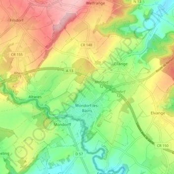
Name: Mondorf-les-Bains topographic map, elevation, terrain.
Location: Mondorf-les-Bains, Canton Remich, Luxembourg (49.49299 6.24058 49.53438 6.32426)
Average elevation: 243 m
Minimum elevation: 165 m
Maximum elevation: 346 m
Other topographic maps
Click on a map to view its topography, its elevation and its terrain.
Schengen
Luxembourg > Canton Remich > Schengen
Schengen, Canton Remich, Luxembourg
Average elevation: 233 m
Brill
Luxembourg > Canton Remich > Altwies
Brill, Altwies, Mondorf-les-Bains, Canton Remich, 5611, Luxembourg
Average elevation: 229 m
Rolling
Rolling, Bous, Canton Remich, 5443, Luxembourg
Average elevation: 211 m
Baggerweieren Haff Réimech
Luxembourg > Canton Remich > Wintrange
Baggerweieren Haff Réimech, Dentzescheck, Wintrange, Schengen, Canton Remich, 5441, Luxembourg
Average elevation: 172 m
Wintrange
Wintrange, Schengen, Canton Remich, 5440, Luxembourg
Average elevation: 197 m
Greiveldange
Greiveldange, Stadtbredimus, Canton Remich, 5426, Luxembourg
Average elevation: 211 m
Ellange
Ellange, Mondorf-les-Bains, Canton Remich, 5690, Luxembourg
Average elevation: 246 m