
West Central Okanagan Electoral Area topographic map
Interactive map
Click on the map to display elevation.
About this map
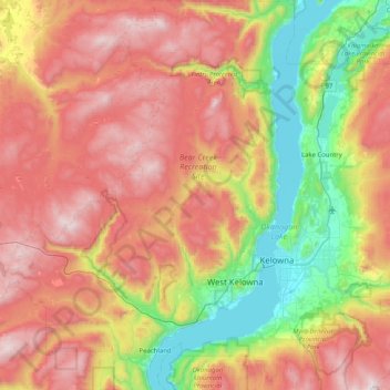
Name: West Central Okanagan Electoral Area topographic map, elevation, terrain.
Average elevation: 1,087 m
Minimum elevation: 336 m
Maximum elevation: 1,981 m
Other topographic maps
Click on a map to view its topography, its elevation and its terrain.
Kelowna
Canada > British Columbia > Regional District of Central Okanagan
Kelowna, Regional District of Central Okanagan, British Columbia, Canada
Average elevation: 704 m
West Kelowna
Canada > British Columbia > Regional District of Central Okanagan
West Kelowna, Westbank First Nation #9, Regional District of Central Okanagan, British Columbia, Canada
Average elevation: 649 m
Hydraulic Lake
Canada > British Columbia > Regional District of Central Okanagan > East Central Okanagan Electoral Area
Hydraulic Lake, East Central Okanagan Electoral Area, Regional District of Central Okanagan, British Columbia, Canada
Average elevation: 1,266 m
Okanagan Lake
Canada > British Columbia > Regional District of Central Okanagan > Kelowna
Okanagan Lake, Kelowna, Westbank First Nation #9, Regional District of Central Okanagan, British Columbia, Canada
Average elevation: 1,194 m
Lake Country
Canada > British Columbia > Regional District of Central Okanagan
Lake Country, Regional District of Central Okanagan, British Columbia, Canada
Average elevation: 650 m
Little White Mountain
Canada > British Columbia > Regional District of Central Okanagan > East Central Okanagan Electoral Area
Little White Mountain, East Central Okanagan Electoral Area, Regional District of Central Okanagan, British Columbia, Canada
Average elevation: 1,935 m
Peachland
Canada > British Columbia > Regional District of Central Okanagan
Peachland, Regional District of Central Okanagan, British Columbia, Canada
Average elevation: 628 m
Fintry
Canada > British Columbia > Regional District of Central Okanagan > West Central Okanagan Electoral Area
Fintry, West Central Okanagan Electoral Area, Regional District of Central Okanagan, British Columbia, Canada
Average elevation: 437 m
The Commons Field
Canada > British Columbia > Regional District of Central Okanagan > Kelowna
The Commons Field, University South, Kelowna, Regional District of Central Okanagan, British Columbia, Canada
Average elevation: 442 m
Oyama Lake
Canada > British Columbia > Regional District of Central Okanagan > East Central Okanagan Electoral Area
Oyama Lake, East Central Okanagan Electoral Area, Regional District of Central Okanagan, British Columbia, Canada
Average elevation: 1,387 m
Christie Lake
Canada > British Columbia > Regional District of Central Okanagan > West Central Okanagan Electoral Area
Christie Lake, West Central Okanagan Electoral Area, Regional District of Central Okanagan, British Columbia, Canada
Average elevation: 1,448 m
Browne Lake
Canada > British Columbia > Regional District of Central Okanagan > East Central Okanagan Electoral Area
Browne Lake, East Central Okanagan Electoral Area, Regional District of Central Okanagan, British Columbia, Canada
Average elevation: 1,326 m
Damer Lake
Canada > British Columbia > Regional District of Central Okanagan > East Central Okanagan Electoral Area
Damer Lake, East Central Okanagan Electoral Area, Regional District of Central Okanagan, British Columbia, Canada
Average elevation: 1,353 m
Oyama
Canada > British Columbia > Regional District of Central Okanagan > Lake Country > Oyama
Oyama, Lake Country, Regional District of Central Okanagan, British Columbia, V4V 1G0, Canada
Average elevation: 481 m
West Kelowna
Canada > British Columbia > Regional District of Central Okanagan > West Kelowna
West Kelowna, Regional District of Central Okanagan, British Columbia, V1Z 2T6, Canada
Average elevation: 871 m
Lake Country
Canada > British Columbia > Regional District of Central Okanagan > Lake Country > Lake Country
Lake Country, Regional District of Central Okanagan, British Columbia, V4V 2M1, Canada
Average elevation: 528 m
Black Knight Mountain
Canada > British Columbia > Regional District of Central Okanagan > East Central Okanagan Electoral Area
Black Knight Mountain, East Central Okanagan Electoral Area, Regional District of Central Okanagan, British Columbia, V1X 7K5, Canada
Average elevation: 992 m
Lambly Lake
Canada > British Columbia > Regional District of Central Okanagan > West Central Okanagan Electoral Area
Lambly Lake, West Central Okanagan Electoral Area, Regional District of Central Okanagan, British Columbia, Canada
Average elevation: 1,214 m
East Central Okanagan Electoral Area
Canada > British Columbia > Regional District of Central Okanagan
East Central Okanagan Electoral Area, Regional District of Central Okanagan, British Columbia, Canada
Average elevation: 1,246 m
Mount Boucherie (West Face)
Canada > British Columbia > Regional District of Central Okanagan > West Kelowna
Mount Boucherie (West Face), West Kelowna, Regional District of Central Okanagan, British Columbia, V1Z 2T6, Canada
Average elevation: 506 m