Geolocate

Rovira topographic map

Click on the map to display elevation.

About this map

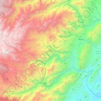
Name: Rovira topographic map, elevation, terrain.

Location: Rovira, Centro, Tolima, RAP Eje Cafetero, Colombia (4.03905 -75.56677 4.34659 -75.14094)

Average elevation: 1,863 m

Minimum elevation: 371 m

Maximum elevation: 3,929 m

Other topographic maps

Click on a map to view its topography, its elevation and its terrain.

Parque Mitológico

Colombia > Tolima > Espinal

Average elevation: 325 m

Toche

Colombia > Tolima

Average elevation: 2,357 m

Alto De Letras

Colombia > Tolima

Average elevation: 1,511 m

Piedras

Colombia > Tolima > Piedras

Average elevation: 415 m

Gaitan

Colombia > Tolima > Gaitan

Average elevation: 1,198 m

Gear up for your next adventure:

🧢Outdoor Visor - Breathable visor for sunny hikes
🛶Kayak Dry Bag - Waterproof storage for kayaking adventures
🗺️Topographic Maps - Detailed maps to explore trails, mountains, and wilderness areas
🥾Hiking Gaiters - Protect legs and shoes from mud, snow, and debris
🧥Waterproof Pants - Keep dry during rainy hiking conditions

As an Amazon Associate, this site earns from qualifying purchases at no extra cost to you.