Geolocate

Dublin topographic map

Click on the map to display elevation.

About this map

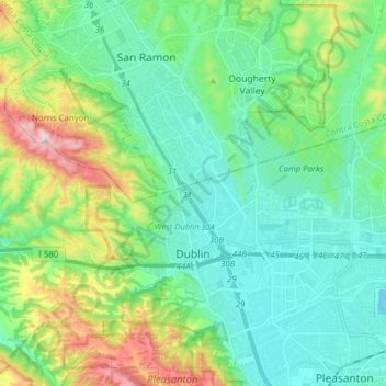
Name: Dublin topographic map, elevation, terrain.

Location: Dublin, Alameda County, California, 94568, United States (37.69776 -121.98780 37.74510 -121.83244)

Average elevation: 202 m

Minimum elevation: 81 m

Maximum elevation: 560 m

Other topographic maps

Click on a map to view its topography, its elevation and its terrain.

Cherryland

United States > California > Alameda County

Average elevation: 27 m

Gear up for your next adventure:

🧶550 Survival Paracord - Versatile utility cord for emergency repairs and rigging
🔋Lithium AA Batteries - Long-lasting power that performs in extreme cold
🛶Kayak Accessories - Essential gear for safe and fun kayaking adventures
🔦LED Headlamp - Hands-free lighting for early morning starts or late finishes
🔋Emergency Crank Radio - Weather alerts and power without needing batteries

As an Amazon Associate, this site earns from qualifying purchases at no extra cost to you.