Geolocate

Callahan topographic map

Click on the map to display elevation.

About this map

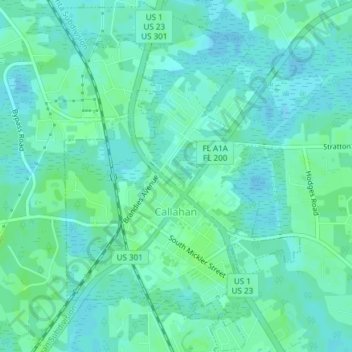
Name: Callahan topographic map, elevation, terrain.

Location: Callahan, Nassau County, Florida, 32011, United States (30.54929 -81.84360 30.58159 -81.81739)

Average elevation: 6 m

Minimum elevation: 2 m

Maximum elevation: 10 m

Other topographic maps

Click on a map to view its topography, its elevation and its terrain.

Hero

United States > Florida > Nassau County

Average elevation: 5 m

Chester

United States > Florida > Nassau County

Average elevation: 4 m

Kings Ferry

United States > Florida > Nassau County

Average elevation: 4 m

Gear up for your next adventure:

🥾Waterproof Hiking Boots - Boots keeping your feet dry in wet conditions
🥾Waterproof Hiking Shoes - Durable shoes for wet and rugged trails
🛁Quick-Dry Microfiber Towel - Space-saving towel that dries rapidly on the move
🧦Merino Wool Socks - Moisture-wicking comfort for long-distance hiking
🥤Collapsible Travel Cup - Saves space and weight in your mess kit

As an Amazon Associate, this site earns from qualifying purchases at no extra cost to you.