Geolocate

Littlehampton topographic map

Click on the map to display elevation.

About this map

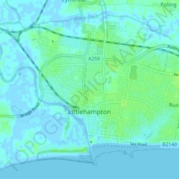
Name: Littlehampton topographic map, elevation, terrain.

Location: Littlehampton, Arun, West Sussex, England, United Kingdom (50.79780 -0.57612 50.83089 -0.51433)

Average elevation: 3 m

Minimum elevation: -4 m

Maximum elevation: 9 m

Other topographic maps

Click on a map to view its topography, its elevation and its terrain.

Fontwell

United Kingdom > England > West Sussex > Arun

Average elevation: 31 m

Eastergate

United Kingdom > England > West Sussex > Arun

Average elevation: 12 m

Shripney

United Kingdom > England > West Sussex > Arun

Average elevation: 3 m

Wick

United Kingdom > England > West Sussex > Arun > Littlehampton > Lyminster

Average elevation: 3 m

Eastergate

United Kingdom > England > West Sussex > Arun

Average elevation: 12 m

Barnham

United Kingdom > England > West Sussex > Arun

Average elevation: 6 m

Bognor Regis

United Kingdom > England > West Sussex > Arun > Nyetimber

Average elevation: 2 m

Nyetimber

United Kingdom > England > West Sussex > Arun

Average elevation: 3 m

Lidsey Rife

United Kingdom > England > West Sussex > Arun > Felpham

Average elevation: 3 m

Elmer

United Kingdom > England > West Sussex > Arun

Average elevation: 2 m

North Bersted

United Kingdom > England > West Sussex > Arun

Average elevation: 3 m

Binsted

United Kingdom > England > West Sussex > Arun > Walberton

Average elevation: 23 m

Gear up for your next adventure:

🚲Heavy Duty Bike Lock - Secure your bike at the trailhead or during stops
🥾Mountaineering Boots - Supportive boots for climbing and high-altitude hiking
🐕Hiking Dog Pack - Let your canine companion carry their own water and food
👟Leg Gaiters - Keep debris, mud, and snow out of your boots
🧦Hiking Liner Socks - Thin base layer to prevent friction and blisters

As an Amazon Associate, this site earns from qualifying purchases at no extra cost to you.