Geolocate

Leonard topographic map

Click on the map to display elevation.

About this map

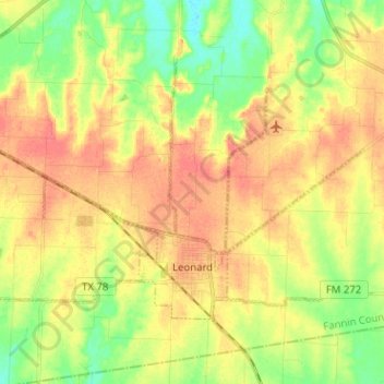
Name: Leonard topographic map, elevation, terrain.

Location: Leonard, Fannin County, Texas, 75452, United States (33.36827 -96.31154 33.43998 -96.18468)

Average elevation: 210 m

Minimum elevation: 182 m

Maximum elevation: 233 m

Other topographic maps

Click on a map to view its topography, its elevation and its terrain.

Boyd

United States > Texas > Fannin County

Average elevation: 184 m

Post Oak

United States > Texas > Fannin County

Average elevation: 179 m

Ravenna

United States > Texas > Fannin County > Ravenna

Average elevation: 177 m

Randolph

United States > Texas > Fannin County

Average elevation: 201 m

Indian Creek

United States > Texas > Fannin County > Trenton

Average elevation: 217 m

Gear up for your next adventure:

🧭GPS Outdoor Watch - Smart watch for navigation and fitness tracking in nature
🧥Softshell Jacket - Windproof and breathable jacket for hiking
💡Compact LED Flashlight - Powerful and portable flashlight for outdoor use
💧Hydration Pack - Hands-free hydration system for long hikes
🥾Hiking Shoes - Durable and comfortable shoes for trail hiking

As an Amazon Associate, this site earns from qualifying purchases at no extra cost to you.