
Make a donation
Gear up for your next adventure:
As an Amazon Associate, this site earns from qualifying purchases at no extra cost to you.
Hseni topographic map
Click on the map to display elevation.
Make a donation
Gear up for your next adventure:
As an Amazon Associate, this site earns from qualifying purchases at no extra cost to you.
Hseni
The southern portion has much more flat land, along the, line of the Nam Tu, its tributaries the Nam Yao and the Nam Nim, and the Nam Yek flowing into the Salween. This was formerly densely populated, and still remains the most valuable portion of the state. A range running westwards from the Salween, and marking the southern border of the rift in the hills, divides North from South Theinni. Both north and south of the Nam Tu there are many peaks which rise to 6,000 feet (1,800 m), and several over 7,000 feet (2,100 m). The northern portion is almost consistent enough in its altitude of about 4,000 feet (1,200 m) to be called a plateau. It has large, grassy, upland downs. This part of the state has fallen almost entirely into the hands of the Kachins.
Make a donation
Gear up for your next adventure:
As an Amazon Associate, this site earns from qualifying purchases at no extra cost to you.
About this map
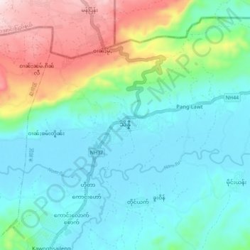
Name: Hseni topographic map, elevation, terrain.
Average elevation: 734 m
Minimum elevation: 602 m
Maximum elevation: 1,121 m
Make a donation
Gear up for your next adventure:
As an Amazon Associate, this site earns from qualifying purchases at no extra cost to you.