Geolocate

Duval Island topographic map

Click on the map to display elevation.

About this map

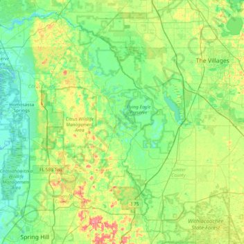
Name: Duval Island topographic map, elevation, terrain.

Location: Duval Island, Citrus County, Florida, 34436, United States (28.44443 -82.59509 29.08443 -81.95509)

Average elevation: 22 m

Minimum elevation: -1 m

Maximum elevation: 87 m

Other topographic maps

Click on a map to view its topography, its elevation and its terrain.

Crystal River

United States > Florida > Citrus County

Average elevation: 4 m

Citrus Hills

United States > Florida > Citrus County

Average elevation: 29 m

Gear up for your next adventure:

🥘Camping Cookware Set - Compact nesting pots and pans for trail cooking
🔦LED Flashlight - Powerful and long-lasting flashlight for camping and emergencies
🧦Hiking Socks - Moisture-wicking and comfortable socks for long hikes
🛏️Sleeping Bag - Warm and compact sleeping bags for outdoor camping
🧊Insulated Water Bottle - Keeps drinks cold in summer and prevents freezing in winter

As an Amazon Associate, this site earns from qualifying purchases at no extra cost to you.