Geolocate

Mwea topographic map

Click on the map to display elevation.

About this map

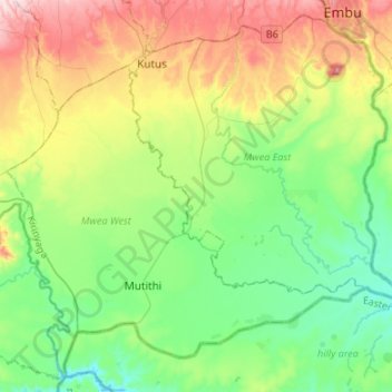
Name: Mwea topographic map, elevation, terrain.

Location: Mwea, Mwea East, Kirinyaga County, Central Kenya, Kenya (-0.78741 37.22824 -0.54009 37.49610)

Average elevation: 1,194 m

Minimum elevation: 1,051 m

Maximum elevation: 1,487 m

Gear up for your next adventure:

👟Sport Hiking Sandals - Breathable footwear for water crossings and camp rest
🧼Travel Hand Sanitizer - Keep hands clean when water is scarce
🔭Outdoor Binoculars - Lightweight binoculars for birdwatching and hiking
💧Collapsible Water Bottle - Space-saving water bottle for outdoor activities
🥾Approach Shoes - Shoes designed for climbing approaches and rugged trails

As an Amazon Associate, this site earns from qualifying purchases at no extra cost to you.