Geolocate

Lilleshall topographic map

Click on the map to display elevation.

About this map

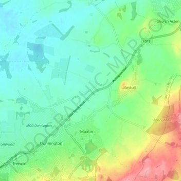
Name: Lilleshall topographic map, elevation, terrain.

Location: Lilleshall, Telford and Wrekin, England, United Kingdom (52.72006 -2.46876 52.75179 -2.37456)

Average elevation: 82 m

Minimum elevation: 50 m

Maximum elevation: 162 m

Other topographic maps

Click on a map to view its topography, its elevation and its terrain.

Gear up for your next adventure:

🥾Mountain Hiking Boots - High-traction boots for rocky terrain
🛶Canoe Life Vest - Safety vest for water sports
🦶Hiking Shoe Insoles - Added support for high arches and long days on feet
🐕Hiking Dog Pack - Let your canine companion carry their own water and food
💧Collapsible Water Bottle - Space-saving water bottle for outdoor activities

As an Amazon Associate, this site earns from qualifying purchases at no extra cost to you.