Geolocate

Littlebourne topographic map

Click on the map to display elevation.

About this map

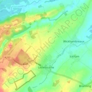
Name: Littlebourne topographic map, elevation, terrain.

Location: Littlebourne, Canterbury, Kent, England, United Kingdom (51.26351 1.12612 51.30254 1.17717)

Average elevation: 21 m

Minimum elevation: -2 m

Maximum elevation: 53 m

Other topographic maps

Click on a map to view its topography, its elevation and its terrain.

Seasalter

United Kingdom > England > Kent > Canterbury

Average elevation: 12 m

Harbledown

United Kingdom > England > Kent > Canterbury

Average elevation: 41 m

Gear up for your next adventure:

🧼Travel Hand Sanitizer - Keep hands clean when water is scarce
🏃Hydration Running Vest - Carry water and maps close to your body for speed
🏕️Camping Hammock - Integrated protection for sleeping between trees
🥾Mountain Hiking Shoes - Shoes with superior grip for mountainous terrain
🥾Lightweight Hiking Boots - Boots for comfort and mobility on long hikes

As an Amazon Associate, this site earns from qualifying purchases at no extra cost to you.