
Fintry topographic map
Interactive map
Click on the map to display elevation.
About this map
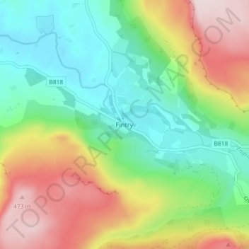
Name: Fintry topographic map, elevation, terrain.
Location: Fintry, Stirling, Scotland, G63 0XN, United Kingdom (56.03315 -4.24342 56.07315 -4.20342)
Average elevation: 230 m
Minimum elevation: 65 m
Maximum elevation: 494 m
Other topographic maps
Click on a map to view its topography, its elevation and its terrain.
Callander
United Kingdom > Scotland > Stirling
Callander, Stirling, Scotland, FK17 8DZ, United Kingdom
Average elevation: 203 m
Kinlochard
United Kingdom > Scotland > Stirling > Kinlochard
Kinlochard, Stirling, Scotland, FK8 3TW, United Kingdom
Average elevation: 177 m
Tyndrum
United Kingdom > Scotland > Stirling > Tyndrum
Tyndrum, Stirling, Scotland, FK20, United Kingdom
Average elevation: 358 m