
Make a donation
Gear up for your next adventure:
As an Amazon Associate, this site earns from qualifying purchases at no extra cost to you.
Les Mottets topographic map
Click on the map to display elevation.
Make a donation
Gear up for your next adventure:
As an Amazon Associate, this site earns from qualifying purchases at no extra cost to you.
About this map
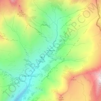
Name: Les Mottets topographic map, elevation, terrain.
Average elevation: 2,254 m
Minimum elevation: 1,682 m
Maximum elevation: 3,062 m
Make a donation
Gear up for your next adventure:
As an Amazon Associate, this site earns from qualifying purchases at no extra cost to you.
Other topographic maps
Click on a map to view its topography, its elevation and its terrain.
Charmettoger
France > Auvergne-Rhône-Alpes > Savoie > Bourg-Saint-Maurice > Arc 1800
Average elevation: 1,693 m
Fort de la Platte
France > Auvergne-Rhône-Alpes > Savoie > Bourg-Saint-Maurice > Les Échines Dessous
Average elevation: 1,773 m
Le Chantel
France > Auvergne-Rhône-Alpes > Savoie > Bourg-Saint-Maurice > Arc 1800
Average elevation: 1,775 m
Make a donation
Gear up for your next adventure:
As an Amazon Associate, this site earns from qualifying purchases at no extra cost to you.
Le Charvet
France > Auvergne-Rhône-Alpes > Savoie > Bourg-Saint-Maurice > Arc 1800
Average elevation: 1,651 m