Geolocate

Piadena topographic map

Click on the map to display elevation.

About this map

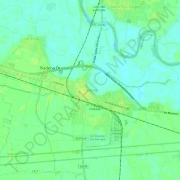
Name: Piadena topographic map, elevation, terrain.

Location: Piadena, Piadena Drizzona, Cremona, Lombardy, 26034, Italy (45.11086 10.34875 45.15086 10.38875)

Average elevation: 31 m

Minimum elevation: 24 m

Maximum elevation: 38 m

Other topographic maps

Click on a map to view its topography, its elevation and its terrain.

Monte Cremasco

Italy > Lombardy > Cremona

Average elevation: 81 m

Cicognolo

Italy > Lombardy > Cremona

Average elevation: 42 m

Bagnolo Cremasco

Italy > Lombardy > Cremona

Average elevation: 79 m

Gear up for your next adventure:

👟Trail Running Shoes - Agile footwear for fast-paced topographic exploration
🛶Kayak Accessories - Essential gear for safe and fun kayaking adventures
🥾All-Terrain Hiking Boots - Versatile boots for varied hiking conditions
💡LED Headlamp - Hands-free illumination for night hiking and camping
🍽️Titanium Camping Spork - Ultralight and indestructible eating utensil

As an Amazon Associate, this site earns from qualifying purchases at no extra cost to you.