
Make a donation
Gear up for your next adventure:
As an Amazon Associate, this site earns from qualifying purchases at no extra cost to you.
Idaho City topographic map
Click on the map to display elevation.
Make a donation
Gear up for your next adventure:
As an Amazon Associate, this site earns from qualifying purchases at no extra cost to you.
Idaho City
Idaho City is located at 43°49′43″N 115°49′56″W / 43.82861°N 115.83222°W / 43.82861; -115.83222 (43.828513, -115.832175), at an elevation of 3,907 feet (1,191 m) above sea level.
Make a donation
Gear up for your next adventure:
As an Amazon Associate, this site earns from qualifying purchases at no extra cost to you.
About this map
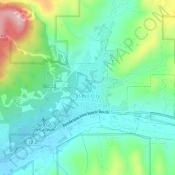
Name: Idaho City topographic map, elevation, terrain.
Location: Idaho City, Boise County, Idaho, United States (43.81955 -115.84513 43.83889 -115.81600)
Average elevation: 1,236 m
Minimum elevation: 1,172 m
Maximum elevation: 1,405 m
Make a donation
Gear up for your next adventure:
As an Amazon Associate, this site earns from qualifying purchases at no extra cost to you.
Other topographic maps
Click on a map to view its topography, its elevation and its terrain.
Make a donation
Gear up for your next adventure:
As an Amazon Associate, this site earns from qualifying purchases at no extra cost to you.
Make a donation
Gear up for your next adventure:
As an Amazon Associate, this site earns from qualifying purchases at no extra cost to you.