
Hadsel topographic map
Interactive map
Click on the map to display elevation.
About this map
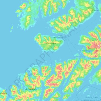
Name: Hadsel topographic map, elevation, terrain.
Location: Hadsel, Nordland, Norway (68.31908 14.13608 68.68797 15.44285)
Average elevation: 101 m
Minimum elevation: -2 m
Maximum elevation: 1,204 m
Other topographic maps
Click on a map to view its topography, its elevation and its terrain.
Ballangen - Bálák
Ballangen - Bálák, Narvik, Nordland, Norway
Average elevation: 91 m
Stuorgiedde - Storjorda
Stuorgiedde - Storjorda, Hamarøy, Nordland, 8275, Norway
Average elevation: 42 m