Geolocate

Carlisle topographic map

Click on the map to display elevation.

About this map

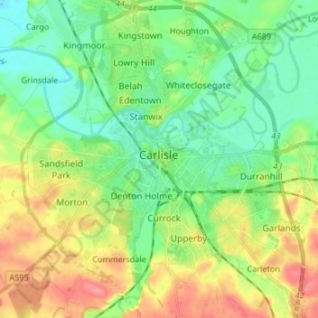
Name: Carlisle topographic map, elevation, terrain.

Location: Carlisle, Cumberland, England, United Kingdom (54.85565 -2.98940 54.93207 -2.87749)

Average elevation: 31 m

Minimum elevation: 5 m

Maximum elevation: 75 m

Other topographic maps

Click on a map to view its topography, its elevation and its terrain.

Cold Fell

United Kingdom > England > Cumberland > Castle Carrock

Average elevation: 517 m

Ennerdale Bridge

United Kingdom > England > Cumberland

Average elevation: 187 m

Bewcastle

United Kingdom > England > Cumberland

Average elevation: 276 m

Borrowdale

United Kingdom > England > Cumberland

Average elevation: 384 m

Harker

United Kingdom > England > Cumberland

Average elevation: 24 m

Rockcliffe

United Kingdom > England > Cumberland

Average elevation: 20 m

Gear up for your next adventure:

🧢Outdoor Cap - Protective cap for sun and rain during hikes
🧥Insulated Jacket - Keep warm in cold outdoor conditions
🛁Quick-Dry Microfiber Towel - Space-saving towel that dries rapidly on the move
🚲Handlebar Phone Mount - View topographic-map.com live while cycling
💧Filtered Water Bottle - Safe drinking water on the go

As an Amazon Associate, this site earns from qualifying purchases at no extra cost to you.