Geolocate

Bewcastle topographic map

Click on the map to display elevation.

About this map

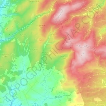
Name: Bewcastle topographic map, elevation, terrain.

Location: Bewcastle, Cumberland, England, United Kingdom (55.05231 -2.81390 55.18898 -2.58260)

Average elevation: 276 m

Minimum elevation: 82 m

Maximum elevation: 516 m

Other topographic maps

Click on a map to view its topography, its elevation and its terrain.

Cold Fell

United Kingdom > England > Cumberland > Castle Carrock

Average elevation: 517 m

Ennerdale Bridge

United Kingdom > England > Cumberland

Average elevation: 187 m

Harker

United Kingdom > England > Cumberland

Average elevation: 24 m

Carlisle

United Kingdom > England > Cumberland

Average elevation: 31 m

Gear up for your next adventure:

🚑Survival Whistle - Signal for help across long distances in mountains
🧶550 Survival Paracord - Versatile utility cord for emergency repairs and rigging
🧥Insulated Jacket - Keep warm in cold outdoor conditions
🪑Insulated Seat Pad - Protect your seat from cold rocks and wet logs
🧊Portable Cooler - Keep food and drinks cold during outdoor adventures

As an Amazon Associate, this site earns from qualifying purchases at no extra cost to you.