
Make a donation
Gear up for your next adventure:
As an Amazon Associate, this site earns from qualifying purchases at no extra cost to you.
Oudenburg topographic map
Click on the map to display elevation.
Make a donation
Gear up for your next adventure:
As an Amazon Associate, this site earns from qualifying purchases at no extra cost to you.
Oudenburg
Oudenburg ligt aan de rand van het West-Vlaams poldergebied op een hoogte van ongeveer 3 meter. Oudenburg ligt aan het Kanaal Plassendale-Nieuwpoort. Natuurgebieden zijn het Oostends Krekengebied, 't Pompje en Schorreweide.
Make a donation
Gear up for your next adventure:
As an Amazon Associate, this site earns from qualifying purchases at no extra cost to you.
About this map
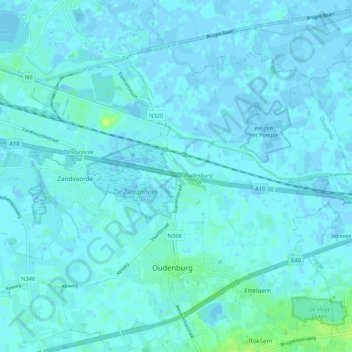
Name: Oudenburg topographic map, elevation, terrain.
Location: Oudenburg, Oostende, West-Vlaanderen, Vlaanderen, België (51.17831 2.93627 51.22446 3.04145)
Average elevation: 2 m
Minimum elevation: -3 m
Maximum elevation: 13 m
Make a donation
Gear up for your next adventure:
As an Amazon Associate, this site earns from qualifying purchases at no extra cost to you.
Other topographic maps
Click on a map to view its topography, its elevation and its terrain.
De Meiboom
België > West-Vlaanderen > Oostende > Oudenburg > Roksem > De Meiboom
Average elevation: 6 m