
Catsfield topographic map
Click on the map to display elevation.
About this map
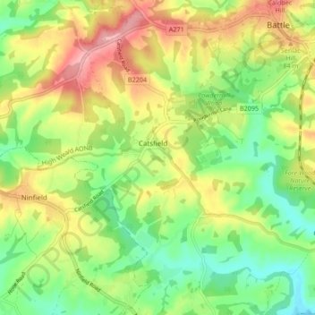
Name: Catsfield topographic map, elevation, terrain.
Location: Catsfield, Rother, East Sussex, England, United Kingdom (50.87282 0.40648 50.91723 0.49040)
Average elevation: 53 m
Minimum elevation: 1 m
Maximum elevation: 118 m
Other topographic maps
Click on a map to view its topography, its elevation and its terrain.
Highwoods SSSI
United Kingdom > England > East Sussex > Rother > Bexhill-on-Sea
Average elevation: 28 m
Northbridge Street
United Kingdom > England > East Sussex > Rother > Robertsbridge
Average elevation: 40 m
John's Cross
United Kingdom > England > East Sussex > Rother > Mountfield > John's Cross
Average elevation: 53 m
Union Street
United Kingdom > England > East Sussex > Rother > Flimwell > Union Street
Average elevation: 97 m
Battle of Hastings
United Kingdom > England > East Sussex > Rother > Catsfield
Battle Abbey was founded by William at the site of the battle. According to 12th-century sources, William made a vow to found the abbey, and the high altar of the church was placed at the site where Harold had died. More likely, the foundation was imposed on William by papal legates in 1070. The topography of…
Average elevation: 60 m