Geolocate

Faulkland topographic map

Click on the map to display elevation.

About this map

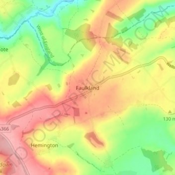
Name: Faulkland topographic map, elevation, terrain.

Location: Faulkland, Mendip District, Somerset, England, BA3 5WH, United Kingdom (51.26949 -2.39790 51.30949 -2.35790)

Average elevation: 124 m

Minimum elevation: 53 m

Maximum elevation: 190 m

Other topographic maps

Click on a map to view its topography, its elevation and its terrain.

Upton Noble

United Kingdom > England > Somerset > Mendip District

Average elevation: 151 m

Gear up for your next adventure:

🥾Mountain Hiking Shoes - Shoes with superior grip for mountainous terrain
🍽️Titanium Camping Spork - Ultralight and indestructible eating utensil
🥾Lightweight Hiking Shoes - Comfortable shoes for day hikes
🥾Trail Hiking Boots - Supportive boots for rough trails
🔪Outdoor Multitool - Versatile tool for repairs and food prep in the wild

As an Amazon Associate, this site earns from qualifying purchases at no extra cost to you.