Geolocate

Monteu topographic map

Click on the map to display elevation.

About this map

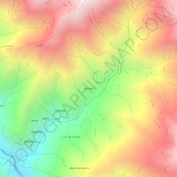
Name: Monteu topographic map, elevation, terrain.

Location: Monteu, Ingria, Torino, Piemonte, Italia (45.45790 7.58700 45.49790 7.62700)

Average elevation: 1,537 m

Minimum elevation: 618 m

Maximum elevation: 2,377 m

Other topographic maps

Click on a map to view its topography, its elevation and its terrain.

Val Soana

Italia > Piemonte > Torino > Ingria

Average elevation: 1,456 m

Gear up for your next adventure:

Backpacking Tent - Lightweight tent for long-distance hiking trips
🔦UV Flashlight - Detect minerals or specific insects in the dark
🧳Compression Sacks - Maximize space in your backpack by shrinking gear
🔭Outdoor Binoculars - Lightweight binoculars for birdwatching and hiking
🥾Trail Running Shoes - Lightweight and durable shoes for trail running

As an Amazon Associate, this site earns from qualifying purchases at no extra cost to you.