
Senneterre (ville) topographic map
Interactive map
Click on the map to display elevation.
About this map
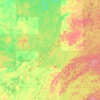
Name: Senneterre (ville) topographic map, elevation, terrain.
Average elevation: 356 m
Minimum elevation: 266 m
Maximum elevation: 628 m
Other topographic maps
Click on a map to view its topography, its elevation and its terrain.
Lac Julien
Canada > Quebec > La Vallée-de-l'Or > Senneterre (ville)
Lac Julien, Senneterre (ville), La Vallée-de-l'Or, Abitibi-Témiscamingue, Quebec, Canada
Average elevation: 432 m
Val-d'Or
Canada > Quebec > La Vallée-de-l'Or
Val-d'Or, La Vallée-de-l'Or, Abitibi-Témiscamingue, Quebec, Canada
Average elevation: 331 m
Lac Andou
Canada > Quebec > La Vallée-de-l'Or > Réservoir-Dozois
Lac Andou, Réservoir-Dozois, La Vallée-de-l'Or, Abitibi-Témiscamingue, Quebec, Canada
Average elevation: 357 m
Dubuisson
Canada > Quebec > La Vallée-de-l'Or > Val-d'Or
Dubuisson, Val-d'Or, La Vallée-de-l'Or, Abitibi-Témiscamingue, Quebec, J9P 4N7, Canada
Average elevation: 300 m
Malartic
Canada > Quebec > La Vallée-de-l'Or
Malartic, La Vallée-de-l'Or, Abitibi-Témiscamingue, Quebec, J0Y 1Z0, Canada
Average elevation: 318 m