
Make a donation
Gear up for your next adventure:
As an Amazon Associate, this site earns from qualifying purchases at no extra cost to you.
Homs Governorate topographic map
Click on the map to display elevation.
Make a donation
Gear up for your next adventure:
As an Amazon Associate, this site earns from qualifying purchases at no extra cost to you.
About this map
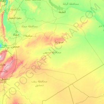
Name: Homs Governorate topographic map, elevation, terrain.
Location: Homs Governorate, Syria (33.55189 36.10542 35.39111 40.16275)
Average elevation: 604 m
Minimum elevation: 95 m
Maximum elevation: 3,015 m
Make a donation
Gear up for your next adventure:
As an Amazon Associate, this site earns from qualifying purchases at no extra cost to you.
Other topographic maps
Click on a map to view its topography, its elevation and its terrain.
Tadmur
With the elevation of Palmyra to a colonia around 213–216, the city ceased being subject to Roman provincial governors and taxes. Palmyra incorporated Roman institutions into its system while keeping many of its former ones. The council remained, and the strategos designated one of two annually-elected…
Average elevation: 499 m
Make a donation
Gear up for your next adventure:
As an Amazon Associate, this site earns from qualifying purchases at no extra cost to you.
Make a donation
Gear up for your next adventure:
As an Amazon Associate, this site earns from qualifying purchases at no extra cost to you.