Geolocate

Horndean topographic map

Click on the map to display elevation.

About this map

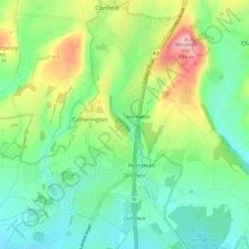
Name: Horndean topographic map, elevation, terrain.

Location: Horndean, East Hampshire, Hampshire, England, United Kingdom (50.89949 -1.04850 50.94534 -0.96656)

Average elevation: 92 m

Minimum elevation: 44 m

Maximum elevation: 192 m

Other topographic maps

Click on a map to view its topography, its elevation and its terrain.

Gear up for your next adventure:

🪑Ultralight Camping Stool - Compact seating for rest stops during long hikes
🛁Quick-Dry Microfiber Towel - Space-saving towel that dries rapidly on the move
🧣Merino Neck Gaiter - Protects against wind, sun, and cold at high altitudes
Camping Essentials - All-in-one gear for a comfortable camping trip
🥾Hiking Shorts - Breathable shorts suitable for summer hikes

As an Amazon Associate, this site earns from qualifying purchases at no extra cost to you.