Geolocate

Vesseaux topographic map

Click on the map to display elevation.

About this map
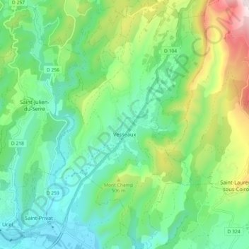
Name: Vesseaux topographic map, elevation, terrain.

Location: Vesseaux, Largentière, Ardèche, Auvergne-Rhône-Alpes, Metropolitan France, 07200, France (44.62111 4.41620 44.68490 4.47106)

Average elevation: 389 m

Minimum elevation: 187 m

Maximum elevation: 877 m

Other topographic maps

Click on a map to view its topography, its elevation and its terrain.

Tabias

France > Auvergne-Rhône-Alpes > Ardèche > Lagorce

Average elevation: 168 m

Beguet

France > Auvergne-Rhône-Alpes > Ardèche > Boffres

Average elevation: 626 m

Valens

France > Auvergne-Rhône-Alpes > Ardèche > Rompon

Average elevation: 236 m

Auriolles

France > Auvergne-Rhône-Alpes > Ardèche

Average elevation: 136 m

Desroches

France > Auvergne-Rhône-Alpes > Ardèche > Lemps

Average elevation: 379 m

Chazotte

France > Auvergne-Rhône-Alpes > Ardèche > Balazuc

Average elevation: 193 m

Cluac

France > Auvergne-Rhône-Alpes > Ardèche > Saint-Basile

Average elevation: 747 m

Benevis

France > Auvergne-Rhône-Alpes > Ardèche > Félines

Average elevation: 322 m

Le Bescut

France > Auvergne-Rhône-Alpes > Ardèche > Veyras

Average elevation: 411 m

Les Matrons

France > Auvergne-Rhône-Alpes > Ardèche > Ardoix

Average elevation: 336 m

Valens

France > Auvergne-Rhône-Alpes > Ardèche > Rompon

Average elevation: 236 m

La Gare

France > Auvergne-Rhône-Alpes > Ardèche > Grospierres

Average elevation: 171 m

Chalos

France > Auvergne-Rhône-Alpes > Ardèche > Rompon

Average elevation: 307 m

Gear up for your next adventure:

🐕Hiking Dog Pack - Let your canine companion carry their own water and food
🎒Backpack Rain Cover - External shield to keep your entire pack dry
🧳Compression Sacks - Maximize space in your backpack by shrinking gear
🧥Waterproof Pants - Keep dry during rainy hiking conditions
🧤Rechargeable Heated Gloves - Extreme warmth for Canadian winter expeditions

As an Amazon Associate, this site earns from qualifying purchases at no extra cost to you.