
Phan Dung topographic map
Interactive map
Click on the map to display elevation.
About this map
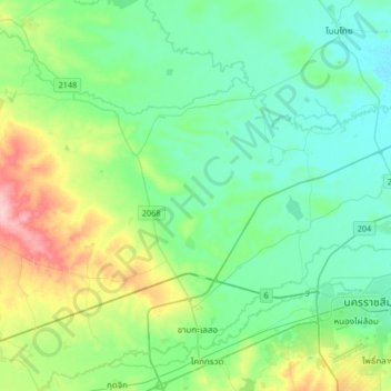
Name: Phan Dung topographic map, elevation, terrain.
Location: Phan Dung, Nakhon Ratchasima Province, Thailand (14.90208 101.78942 15.22208 102.10942)
Average elevation: 202 m
Minimum elevation: 169 m
Maximum elevation: 304 m
Other topographic maps
Click on a map to view its topography, its elevation and its terrain.
Ban Som
Thailand > Nakhon Ratchasima Province > Ban Som
Ban Som, Nakhon Ratchasima Province, Thailand
Average elevation: 159 m
Nakhon Ratchasima
Thailand > Nakhon Ratchasima Province
Nakhon Ratchasima, Hua Thale, Nakhon Ratchasima Province, 30000, Thailand
Average elevation: 195 m