Geolocate

Martin topographic map

Click on the map to display elevation.

About this map

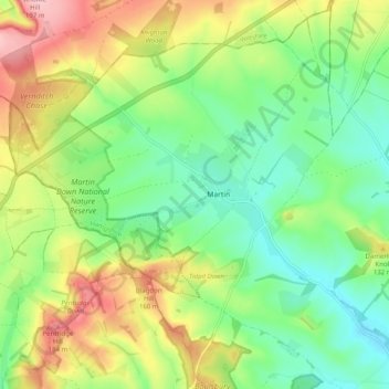
Name: Martin topographic map, elevation, terrain.

Location: Martin, New Forest, Hampshire, England, United Kingdom (50.94336 -1.95728 51.00634 -1.87379)

Average elevation: 103 m

Minimum elevation: 45 m

Maximum elevation: 194 m

Gear up for your next adventure:

🧼Travel Hand Sanitizer - Keep hands clean when water is scarce
📷Outdoor Action Camera - Capture high-elevation views and rugged adventures
🦶Anti-Blister Balm - Prevents friction and hotspots during long ascents
💡Compact LED Flashlight - Powerful and portable flashlight for outdoor use
🥾Approach Boots - Comfortable boots for hiking and climbing approaches

As an Amazon Associate, this site earns from qualifying purchases at no extra cost to you.