Geolocate

Walnut Cove topographic map

Click on the map to display elevation.

About this map

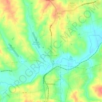
Name: Walnut Cove topographic map, elevation, terrain.

Location: Walnut Cove, Stokes County, North Carolina, United States (36.27498 -80.15314 36.31956 -80.12946)

Average elevation: 206 m

Minimum elevation: 179 m

Maximum elevation: 243 m

Other topographic maps

Click on a map to view its topography, its elevation and its terrain.

Delta

United States > North Carolina > Stokes County

Average elevation: 315 m

Buffalo

United States > North Carolina > Stokes County

Average elevation: 303 m

Germanton

United States > North Carolina > Stokes County

Average elevation: 226 m

Dalton

United States > North Carolina > Stokes County

Average elevation: 287 m

Gear up for your next adventure:

🪑Insulated Seat Pad - Protect your seat from cold rocks and wet logs
🧴Bear Spray Holster - Quick-access carry for essential Canadian wilderness safety
🥾Lightweight Hiking Shoes - Comfortable shoes for day hikes
🕯️Camping Lantern - Illuminates your entire campsite with high-efficiency LEDs
🧴Waterproofing Spray - Restore the DWR coating on jackets and tents

As an Amazon Associate, this site earns from qualifying purchases at no extra cost to you.