
Make a donation
Gear up for your next adventure:
As an Amazon Associate, this site earns from qualifying purchases at no extra cost to you.
Flat Shoals topographic map
Click on the map to display elevation.
Make a donation
Gear up for your next adventure:
As an Amazon Associate, this site earns from qualifying purchases at no extra cost to you.
About this map
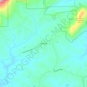
Name: Flat Shoals topographic map, elevation, terrain.
Location: Flat Shoals, Stokes County, North Carolina, United States (36.34514 -80.26366 36.38514 -80.22366)
Average elevation: 332 m
Minimum elevation: 274 m
Maximum elevation: 598 m
Make a donation
Gear up for your next adventure:
As an Amazon Associate, this site earns from qualifying purchases at no extra cost to you.
Other topographic maps
Click on a map to view its topography, its elevation and its terrain.
Hanging Rock State Park
United States > North Carolina > Stokes County > Danbury
Hanging Rock State Park is located in the Sauratown Mountain Range, one of the most easterly mountain ranges in the state. Often called "the mountains away from the mountains," the Sauratown range is made up of monadnocks that are separated from the nearby Blue Ridge Mountains. The Sauratown Mountains lie…
Average elevation: 323 m