Geolocate

Stanford Rivers topographic map

Click on the map to display elevation.

About this map

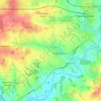
Name: Stanford Rivers topographic map, elevation, terrain.

Location: Stanford Rivers, Epping Forest, Essex, England, United Kingdom (51.65969 0.16225 51.71650 0.24579)

Average elevation: 65 m

Minimum elevation: 29 m

Maximum elevation: 115 m

Gear up for your next adventure:

🥾Trail Running Shoes - Lightweight and durable shoes for trail running
💧Hydration Pack - Hands-free hydration system for long hikes
🧤Rechargeable Heated Gloves - Extreme warmth for Canadian winter expeditions
🥾Approach Shoes - Shoes designed for climbing approaches and rugged trails
🚑Survival Whistle - Signal for help across long distances in mountains

As an Amazon Associate, this site earns from qualifying purchases at no extra cost to you.