Geolocate

Relizane topographic map

Click on the map to display elevation.

About this map

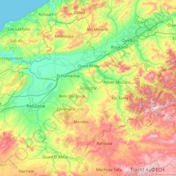
Name: Relizane topographic map, elevation, terrain.

Location: Relizane, Algeria (35.44465 0.22720 36.22803 1.42799)

Average elevation: 384 m

Minimum elevation: 0 m

Maximum elevation: 1,246 m

Other topographic maps

Click on a map to view its topography, its elevation and its terrain.

Djerba

Algeria > Bejaia > Bejaia District > Bejaia > Boulimat

Average elevation: 85 m

El Ferine

Algeria > El Tarf > El Tarf District > Aïn El Assel

Average elevation: 35 m

Taxas

Algeria > Oum El Bouaghi > Sigus District > Sigus

Average elevation: 834 m

Gear up for your next adventure:

🥾Hiking Leggings - Comfortable leggings for outdoor activities
👟Leg Gaiters - Keep debris, mud, and snow out of your boots
💧Collapsible Water Bottle - Space-saving water bottle for outdoor activities
🥾Trail Running Boots - Durable shoes designed for trail running
🔭Compact Monocular - One-handed bird watching and trail spotting

As an Amazon Associate, this site earns from qualifying purchases at no extra cost to you.