
Make a donation
Gear up for your next adventure:
As an Amazon Associate, this site earns from qualifying purchases at no extra cost to you.
San Clemente Island topographic map
Click on the map to display elevation.
Make a donation
Gear up for your next adventure:
As an Amazon Associate, this site earns from qualifying purchases at no extra cost to you.
San Clemente Island
Its highest point is Mount Thirst, at 1965 feet in elevation. The elevation of the island's ridge can impact precipitation, as it can cause atmospheric moisture to condense and cause more intense precipitation. This was a factor in the intense rainstorm that hit San Diego on January 22, 2024.
Make a donation
Gear up for your next adventure:
As an Amazon Associate, this site earns from qualifying purchases at no extra cost to you.
About this map
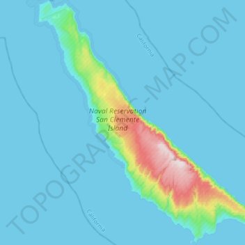
Name: San Clemente Island topographic map, elevation, terrain.
Average elevation: 49 m
Minimum elevation: 0 m
Maximum elevation: 595 m
Make a donation
Gear up for your next adventure:
As an Amazon Associate, this site earns from qualifying purchases at no extra cost to you.
Other topographic maps
Click on a map to view its topography, its elevation and its terrain.
Santa Monica Mountains
United States > California > Los Angeles County > Malibu
On January 17, 2007, an unusually cold storm brought snow in the Santa Monica Mountains. The hills above Malibu picked up three inches (eight centimeters) of snow - the first measurable snow in fifty years. Snow was reported on Boney Peak in the winter of 2005; and in March 2006, snow also fell on the summit…
Average elevation: 288 m
Deer Lake Highlands
United States > California > Los Angeles County > Unincorporated Chatsworth
Average elevation: 421 m
Make a donation
Gear up for your next adventure:
As an Amazon Associate, this site earns from qualifying purchases at no extra cost to you.
Highland Camrose Park
United States > California > Los Angeles County > Los Angeles
Average elevation: 186 m
Make a donation
Gear up for your next adventure:
As an Amazon Associate, this site earns from qualifying purchases at no extra cost to you.
Veterans Administration
United States > California > Los Angeles County > Veterans Administration
Average elevation: 105 m
Palisades del Rey, California
United States > California > Los Angeles County > Los Angeles
Palisades del Rey (also Palisades Del Rey) was a 1921 neighborhood land development by Dickinson & Gillespie Co. that later came to be called the Playa del Rey district of Los Angeles County, California. It lay at an elevation of 135 feet (41 m). All of the houses in this area were custom built, many as beach…
Average elevation: 20 m
Verdugo City
United States > California > Los Angeles County > Glendale > Verdugo City
Average elevation: 472 m
Make a donation
Gear up for your next adventure:
As an Amazon Associate, this site earns from qualifying purchases at no extra cost to you.
Sierra Madre
United States > California > Los Angeles County > Sierra Madre > Sierra Madre
In 1908, the first Mt. Wilson Trail Race was run. This annual race was discontinued during WWII and reestablished in 1966. The 102nd anniversary of the first running of the Mount Wilson Trail Race and the 44th annual race was run in May 2010. Because of rain, mudslides, falling trees, soil erosion and…
Average elevation: 379 m