
Hansen Dam topographic map
Click on the map to display elevation.
About this map
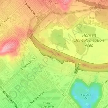
Name: Hansen Dam topographic map, elevation, terrain.
Average elevation: 308 m
Minimum elevation: 229 m
Maximum elevation: 371 m
Other topographic maps
Click on a map to view its topography, its elevation and its terrain.
San Fernando Valley
United States > California > Los Angeles County > Los Angeles
Average elevation: 496 m
Universal City Overlook
United States > California > Los Angeles County > Los Angeles
Average elevation: 278 m
San Fernando Valley
United States > California > Los Angeles County > Los Angeles
Average elevation: 496 m
Santa Susana Mountains
United States > California > Los Angeles County > Los Angeles
Average elevation: 520 m
South Los Angeles
United States > California > Los Angeles County > Los Angeles
Average elevation: 421 m
Will Rogers State Historic Park
United States > California > Los Angeles County > Los Angeles
Average elevation: 152 m
El Escorpion Park
United States > California > Los Angeles County > Los Angeles
Average elevation: 341 m
San Fernando Valley
United States > California > Los Angeles County > Los Angeles
Average elevation: 496 m
Rio de Los Angeles State Park State Recreational Area
United States > California > Los Angeles County > Los Angeles
Average elevation: 141 m