Geolocate

Chancaybaños topographic map

Click on the map to display elevation.

About this map

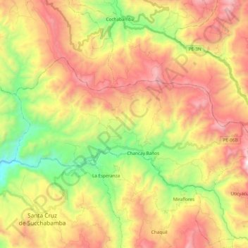
Name: Chancaybaños topographic map, elevation, terrain.

Location: Chancaybaños, Provincia de Santa Cruz, Cajamarca, Perú (-6.60449 -78.96568 -6.50346 -78.77665)

Average elevation: 2,054 m

Minimum elevation: 1,289 m

Maximum elevation: 2,873 m

Other topographic maps

Click on a map to view its topography, its elevation and its terrain.

Chancay Baños

Perú > Cajamarca > Chancaybaños

Average elevation: 1,775 m

Montan Mayo

Perú > Cajamarca > Chancaybaños

Average elevation: 2,362 m

Gear up for your next adventure:

🚲MTB Frame Bag - Carry tools and maps directly on your bicycle frame
🧭GPS Outdoor Watch - Smart watch for navigation and fitness tracking in nature
🥾Mountaineering Boots - Supportive boots for climbing and high-altitude hiking
💧Filtered Water Bottle - Safe drinking water on the go
🧦Hiking Socks - Moisture-wicking and comfortable socks for long hikes

As an Amazon Associate, this site earns from qualifying purchases at no extra cost to you.