Geolocate

Moya topographic map

Click on the map to display elevation.

About this map

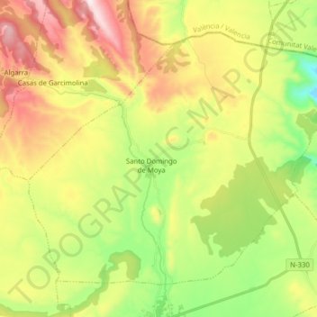
Name: Moya topographic map, elevation, terrain.

Location: Moya, Cuenca, Castile-La Mancha, Spain (39.92143 -1.43050 40.01667 -1.27434)

Average elevation: 1,105 m

Minimum elevation: 797 m

Maximum elevation: 1,503 m

Other topographic maps

Click on a map to view its topography, its elevation and its terrain.

Huelga del Escobar

Spain > Castile-La Mancha > Uña

Average elevation: 1,235 m

Rio Júcar

Spain > Castile-La Mancha > Cuenca

Average elevation: 955 m

El Cobato

Spain > Castile-La Mancha > Cuenca > Huete

Average elevation: 953 m

Aragosa

Spain > Castile-La Mancha > Aragosa

Average elevation: 1,003 m

El Alto

Spain > Castile-La Mancha > Sigüenza

Average elevation: 1,129 m

855

Spain > Castile-La Mancha > Alcantud

Average elevation: 835 m

Gear up for your next adventure:

🛰️Satellite Messenger - Emergency communication for areas with no cell service
🛏️Camping Sleeping Mat - Comfortable mats for sleeping outdoors
🥾Waterproof Hiking Shoes - Durable shoes for wet and rugged trails
🧳Compression Sacks - Maximize space in your backpack by shrinking gear
🏕️Camping Hammock - Integrated protection for sleeping between trees

As an Amazon Associate, this site earns from qualifying purchases at no extra cost to you.