Geolocate

Gallup topographic map

Click on the map to display elevation.

Gallup

Gallup, like most of the interior Mountain West, has a cool semiarid climate (Köppen BSk). The summers are hot during the day, but the high altitude and low humidity mean that nights remain distinctly cool; as late as July 2, 1997, the temperature fell to 31 °F (−1 °C). Despite the large diurnal temperature range, most rain falls in the summer from afternoon thunderstorms. Snow is common and sometimes heavy; the maximum in a month is 29.10 inches (0.74 m) in December 1992 and the most in a year 65.10 inches (1.65 m) between July 1990 and June 1991. Actual snow cover, with the hot sun at Gallup's altitude, however, has never exceeded 13.1 inches (0.33 m), and for no day averages over 3.5 inches (0.089 m).

Wikipedia (CC-BY-SA 3.0)

About this map

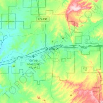
Name: Gallup topographic map, elevation, terrain.

Location: Gallup, McKinley County, New Mexico, 87301, United States (35.49099 -108.84735 35.55211 -108.59959)

Average elevation: 2,067 m

Minimum elevation: 1,946 m

Maximum elevation: 2,401 m

Other topographic maps

Click on a map to view its topography, its elevation and its terrain.

Coolidge

United States > New Mexico > McKinley County

Average elevation: 2,185 m

Dalton Pass

United States > New Mexico > McKinley County

Average elevation: 2,093 m

Ciniza

United States > New Mexico > McKinley County

Average elevation: 2,122 m

Chi Chil Tah

United States > New Mexico > McKinley County

Average elevation: 2,101 m

Tekapo

United States > New Mexico > McKinley County

Average elevation: 1,900 m

Prewitt Lake

United States > New Mexico > McKinley County

Average elevation: 2,393 m

Tekapo

United States > New Mexico > McKinley County

Average elevation: 1,900 m

Umbrella Rock

United States > New Mexico > McKinley County

Average elevation: 2,168 m

Prewitt Lake

United States > New Mexico > McKinley County

Average elevation: 2,393 m

Smith Lake

United States > New Mexico > McKinley County

Average elevation: 2,221 m

Dalton Pass

United States > New Mexico > McKinley County

Average elevation: 2,093 m

Mesa Redondita

United States > New Mexico > McKinley County

Average elevation: 2,225 m

Zuni Pueblo

United States > New Mexico > McKinley County > Zuni

Average elevation: 1,944 m

China Springs

United States > New Mexico > McKinley County

Average elevation: 2,065 m

Gear up for your next adventure:

💡Solar Camping Lamp - Eco-friendly lighting for campsites
❄️Traction Ice Cleats - Slip-on spikes for icy trails and winter hiking
🧥Packable Rain Jacket - Breathable waterproof layer for unpredictable weather
🧤Thermal Hiking Gloves - Grip-enhanced gloves for cold-weather altitude trekking
🧥Fleece Jacket - Warm and lightweight jacket for layering

As an Amazon Associate, this site earns from qualifying purchases at no extra cost to you.