
Lawe topographic map
Interactive map
Click on the map to display elevation.
About this map
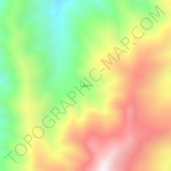
Name: Lawe topographic map, elevation, terrain.
Location: Lawe, Sigi, Sulawesi central, Indonésie (-1.73311 119.83453 -1.69311 119.87453)
Average elevation: 1,305 m
Minimum elevation: 693 m
Maximum elevation: 1,948 m
Other topographic maps
Click on a map to view its topography, its elevation and its terrain.
Atananga
Indonésie > Sulawesi central > Morowali
Atananga, Bungku Barat, Morowali, Sulawesi central, Indonésie
Average elevation: 3 m
Bondat
Indonésie > Sulawesi central > Bondat
Bondat, Banggai, Sulawesi central, Indonésie
Average elevation: 91 m
Beau
Beau, Parigi Moutong, Sulawesi central, Indonésie
Average elevation: 711 m
Lombok
Indonésie > Sulawesi central > Lombok
Lombok, Parigi Moutong, Sulawesi central, Indonésie
Average elevation: 514 m
Tongoa
Indonésie > Sulawesi central > Tongoa
Tongoa, Sigi, Sulawesi central, Indonésie
Average elevation: 1,130 m
Mayumba
Indonésie > Sulawesi central > Mayumba
Mayumba, Sulawesi central, Indonésie
Average elevation: 290 m