Geolocate

Panamaram topographic map

Click on the map to display elevation.

About this map

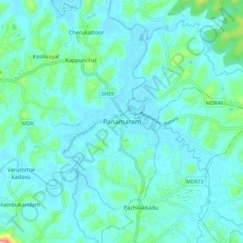
Name: Panamaram topographic map, elevation, terrain.

Location: Panamaram, Mananthavady, Wayanad, Kerala, 670721, India (11.69910 76.03311 11.77910 76.11311)

Average elevation: 736 m

Minimum elevation: 713 m

Maximum elevation: 875 m

Other topographic maps

Click on a map to view its topography, its elevation and its terrain.

Mazhuvannoor

India > Kerala > Mananthavady > Mazhuvannur

Average elevation: 733 m

Vellamunda

India > Kerala > Mananthavady > Peechamcode

Average elevation: 812 m

Kattikulam

India > Kerala > Mananthavady > Kattikkulam

Average elevation: 772 m

Gear up for your next adventure:

🦶Hiking Shoe Insoles - Added support for high arches and long days on feet
🔥Camping Stove - Portable stoves to cook outdoors with ease
🔭Outdoor Binoculars - Lightweight binoculars for birdwatching and hiking
❄️Traction Ice Cleats - Slip-on spikes for icy trails and winter hiking
🧢Outdoor Visor - Breathable visor for sunny hikes

As an Amazon Associate, this site earns from qualifying purchases at no extra cost to you.