Geolocate

Kingsholme topographic map

Click on the map to display elevation.

About this map

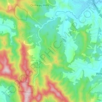
Name: Kingsholme topographic map, elevation, terrain.

Location: Kingsholme, Gold Coast, Queensland, Australia (-27.85849 153.20799 -27.79802 153.26635)

Average elevation: 127 m

Minimum elevation: 5 m

Maximum elevation: 386 m

Other topographic maps

Click on a map to view its topography, its elevation and its terrain.

Guanaba

Australia > Queensland > Gold Coast

Average elevation: 51 m

Pimpama

Australia > Queensland > Gold Coast > Pimpama

Average elevation: 19 m

Reedy Creek

Australia > Queensland > Gold Coast

Average elevation: 16 m

Maudsland

Australia > Queensland > Gold Coast

Average elevation: 43 m

Lower Beechmont

Australia > Queensland > Gold Coast

Average elevation: 297 m

Clagiraba

Australia > Queensland > Gold Coast

Average elevation: 122 m

Binna Burra

Australia > Queensland > Gold Coast

Average elevation: 535 m

Austinville

Australia > Queensland > Gold Coast

Average elevation: 146 m

Gear up for your next adventure:

🌬️Windproof Camp Stove - Efficient cooking even on exposed mountain peaks
🧥Waterproof Hiking Jacket - Protect yourself from rain and wind while hiking
🧥Softshell Hiking Jacket - The perfect balance of wind protection and breathability
🚲Handlebar Phone Mount - View topographic-map.com live while cycling
🔥Emergency Fire Starter - Reliable ignition source for all weather conditions

As an Amazon Associate, this site earns from qualifying purchases at no extra cost to you.