
Belmeken topographic map
Click on the map to display elevation.
Belmeken
Belmeken (Bulgarian: Белмекен) is a summit in the northeastern part of the Rila Mountain in southwestern Bulgaria with a height of 2,626 m. It is built up of granite. Its northern slopes are steep and rise over the Kutlinite cirque. The southern and southeastern slopes are oblique. To the southeast at an altitude of 1,923 m is situated the Belmeken Dam which fuels some of Bulgaria's largest hydro power plants — Chaira Pumped Storage Hydro Power Plant (864 MW), Belmeken Pumped Storage Hydro Power Plant (375 MW), Sestrimo Hydro Power Plant (240 MW) and Momina Klisura Hydroelectric Power Station (120 MW). Close to the summit is the Belmeken High Mountain Sports Complex at an altitude of 2,050 m, used for training, medical and biological research by athletes. The main starting points for climbing are the villages of Yundola and Sestrimo.
About this map
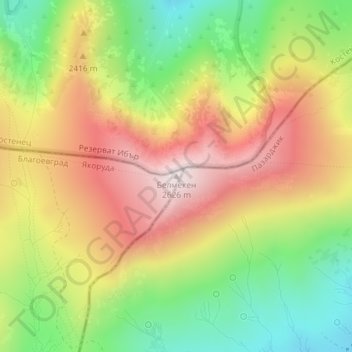
Name: Belmeken topographic map, elevation, terrain.
Location: Belmeken, Yakoruda, Blagoevgrad, Bulgaria (42.18055 23.77145 42.18065 23.77155)
Average elevation: 2,300 m
Minimum elevation: 1,984 m
Maximum elevation: 2,627 m
Other topographic maps
Click on a map to view its topography, its elevation and its terrain.