
Make a donation
Gear up for your next adventure:
As an Amazon Associate, this site earns from qualifying purchases at no extra cost to you.
Réunion topographic map
Click on the map to display elevation.
Make a donation
Gear up for your next adventure:
As an Amazon Associate, this site earns from qualifying purchases at no extra cost to you.
Réunion
Already at the time of the India Route or Route des Indes, Réunion was a French possession located between Cape Town and the Indian trading posts, although far from the Mozambique Channel. Île de Bourbon (its name under the Ancien Régime) was not, however, the preferred position for trade and military. Governor Labourdonnais claimed that Île de France (Mauritius) was a land of opportunity, thanks to its topography and the presence of two natural harbours. He intended Île de Bourbon to be a depot or an emergency base for Île de France.
Make a donation
Gear up for your next adventure:
As an Amazon Associate, this site earns from qualifying purchases at no extra cost to you.
About this map
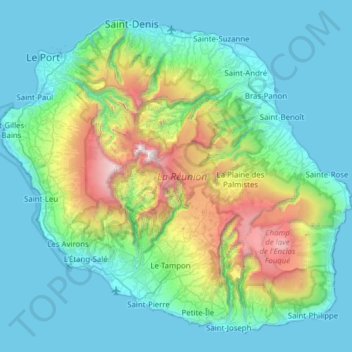
Name: Réunion topographic map, elevation, terrain.
Location: Réunion, France (-21.38971 55.21643 -20.87174 55.83669)
Average elevation: 532 m
Minimum elevation: 0 m
Maximum elevation: 3,043 m
Make a donation
Gear up for your next adventure:
As an Amazon Associate, this site earns from qualifying purchases at no extra cost to you.
Other topographic maps
Click on a map to view its topography, its elevation and its terrain.
La Bérarde
France > Auvergne-Rhône-Alpes > Isère > Saint-Christophe-en-Oisans
Average elevation: 2,307 m
Rivière de Contournement et de Pratiques en Eaux Vives (RICPEV) de l'Île Balzac
France > Centre-Val de Loire > Indre-et-Loire > Tours
Average elevation: 56 m
Val Thorens
France > Auvergne-Rhône-Alpes > Savoy
Val Thorens ([val tɔʁɑ̃]) is a ski town in the Tarentaise Valley in the French Alps at an altitude of 2,300 m (7,500 ft). It is located in the commune of Saint-Martin-de-Belleville in the Savoie department. The resort forms part of the Les Trois Vallées ski area which, with over 600 km of slopes, is one…
Average elevation: 2,516 m
Make a donation
Gear up for your next adventure:
As an Amazon Associate, this site earns from qualifying purchases at no extra cost to you.
Cirque de consolation
France > Bourgogne – Franche-Comté > Doubs > Consolation-Maisonnettes
Average elevation: 732 m
Make a donation
Gear up for your next adventure:
As an Amazon Associate, this site earns from qualifying purchases at no extra cost to you.
Le Blanc Chat
France > Auvergne-Rhône-Alpes > Upper Savoy > Épagny Metz-Tessy
Average elevation: 487 m
Make a donation
Gear up for your next adventure:
As an Amazon Associate, this site earns from qualifying purchases at no extra cost to you.
Les Vieilles Ventes
France > Centre-Loire Valley > Sorel-Moussel > Les Vieilles Ventes
Average elevation: 115 m
Make a donation
Gear up for your next adventure:
As an Amazon Associate, this site earns from qualifying purchases at no extra cost to you.
Le Génetoux
France > Centre-Loire Valley > Indre > Saint-Marcel > Le Génetoux
Average elevation: 151 m
Paris
Paris in its early history had only the rivers Seine and Bièvre for water. From 1809, the Canal de l'Ourcq provided Paris with water from less-polluted rivers to the north-east of the capital. From 1857, the civil engineer Eugène Belgrand, under Napoleon III, oversaw the construction of a series of new…
Average elevation: 75 m
Make a donation
Gear up for your next adventure:
As an Amazon Associate, this site earns from qualifying purchases at no extra cost to you.
Les Ansaults
France > Centre-Loire Valley > Indre-et-Loire > Artannes-sur-Indre > Les Ansaults
Average elevation: 73 m
La Grave de Peille
France > Provence-Alpes-Côte d'Azur > Maritime Alps > Peille > La Grave de Peille
Average elevation: 400 m
Albaron
France > Provence-Alpes-Côte d'Azur > Bouches-du-Rhône > Arles > Albaron
Average elevation: 1 m
Make a donation
Gear up for your next adventure:
As an Amazon Associate, this site earns from qualifying purchases at no extra cost to you.
Les Mignotières
France > Auvergne-Rhône-Alpes > Métropole de Lyon > Genay > Les Mignotières
Average elevation: 230 m
Vautredeix
France > New Aquitaine > Creuse > Saint-Silvain-sous-Toulx > Vautredeix
Average elevation: 448 m
Ruisseau de l'Escourt
France > Auvergne-Rhône-Alpes > Ardèche > Malarce-sur-la-Thines > Fontoux
Average elevation: 313 m
Make a donation
Gear up for your next adventure:
As an Amazon Associate, this site earns from qualifying purchases at no extra cost to you.